After I'd written
the software,
I had to try it out; I had one experienced player and one newcomer to
Harpoon (though he knows the real-world technologies and tactics), and
we played by email over about a week. Here's the after-action report.
The scenario was Gulf Escort Dejá [sic] Vu, an introductory
anti-surface warfare exercise from the Harpoon 4.1 scenario book: two
Iranian
Houdong PTGs,
basically a Chinese copy and upgrade of the Osa, attempt to sink a
tanker in the Persian Gulf and its escorting
Halifax-class frigate.
I made some minor changes to account for the real-world locations,
such as adding a zone round the military airfield at Ras al-Mishab
(near the northern tip of the Gulf) which was the tanker's goal area.
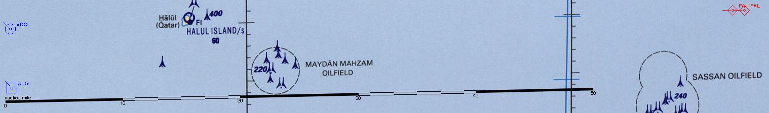
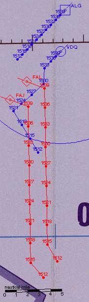
The maps presented here are from a referee's-eye view. The full chart
from which these are extracted is available
here
(but beware, as it's a 9200×6732 bitmap that takes over 14 megabytes).
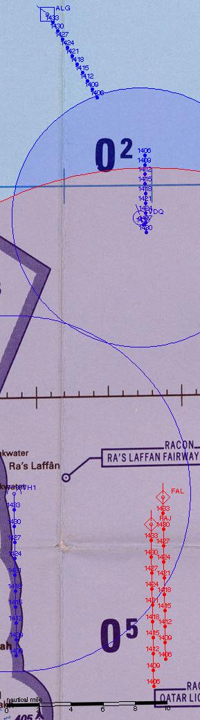
Red chose to keep his two boats together, and they started moving in
towards the start point at 20 knots, with one radar active.
An hour after scenario start, Blue launched Ville de Québec's
helicopter, and as it gained altitude immediately got an ESM detection
on the attackers; it was ordered to move in on that bearing, with
search radar active. (The minimum range on the shading is because
Ville de Québec herself wasn't getting an ESM hit, which would have
been the case if the boats were closer.)
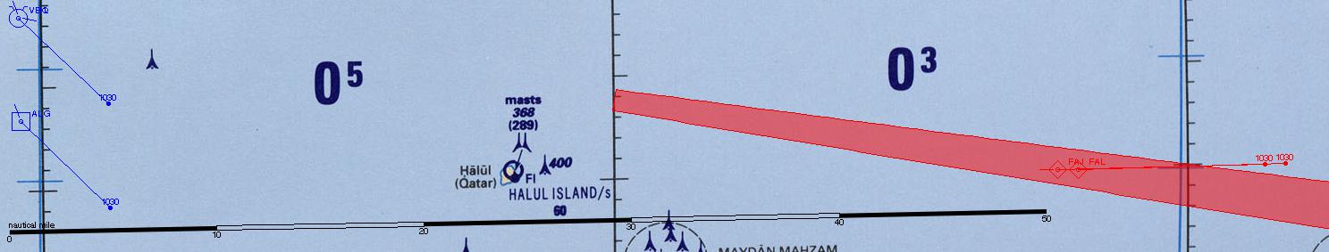
Some ten minutes later, the PTGs detected the helicopter's search
radar (it never came into their visual or gunnery range, but since
both boats were detecting it they had a cross-bearing so I plotted it
on the map anyway).
The PTGs continued to head west towards the Qatari coast. By 1403,
with a good radar image of the whole coast, Red decided that the
convoy wasn't hiding there, and turned north.
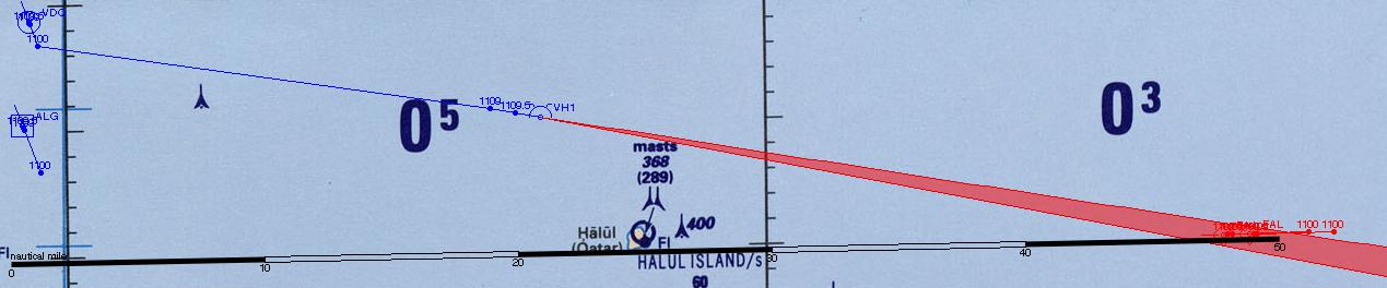
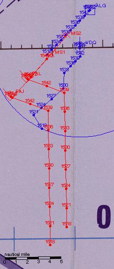
The frigate made a quick sprint to the south to put some distance
between it and the tanker, and turned back towards the north-west just
as the PTGs picked it up on radar. The tanker started to evade,
insofar as it could. The PTGs picked up speed.
Ville de Québec put herself squarely between tanker and attackers.
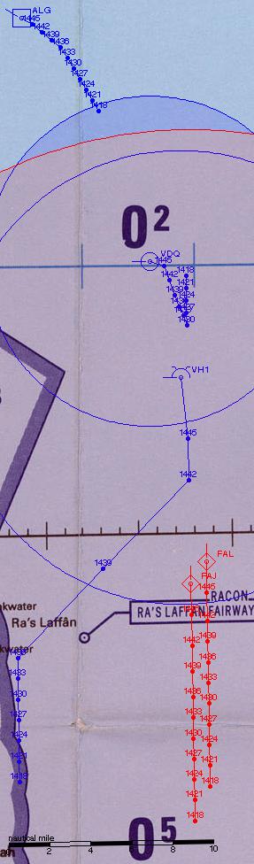
At 1506 the tanker finally came within radar range in spite of its
limited evasive manoeuvres. The helicopter was now pretty low on fuel,
keeping close to Ville de Québec.
Ville de Québec turned to allow the helicopter to land; refuelling
and rearming began immediately.
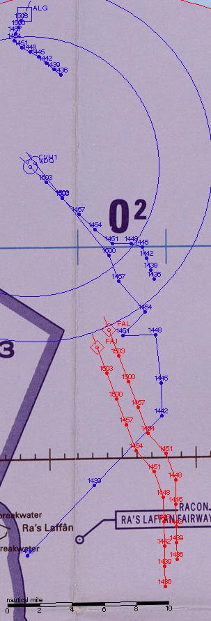
Red was taking advantage of the rules of engagement, going for a
single missile salvo at close range; he planned to fire as he crossed
the tanker's wake, then to make a break for safety.
Things started happening very fast. Red turned and launched all the
missiles from both boats, staying at top speed. Thanks to the short
range, Ville de Québec had only a very brief window in which it
could open up on them without risking hitting the tanker itself.
The first missile swarm was taken down by a lucky Bofors shot and most
of Ville de Québec's Sea Sparrow complement. But only one of the
second swarm was hit; the remaining three struck home against the
tanker. Damage against this massive ship wasn't enough for immediate
sinking or even speed reduction, but critical hits caused major
flooding and loss of cargo (the latter having no game effect; given
that the tanker's heading north-westwards through the Gulf, one
assumes that there's no oil on board).
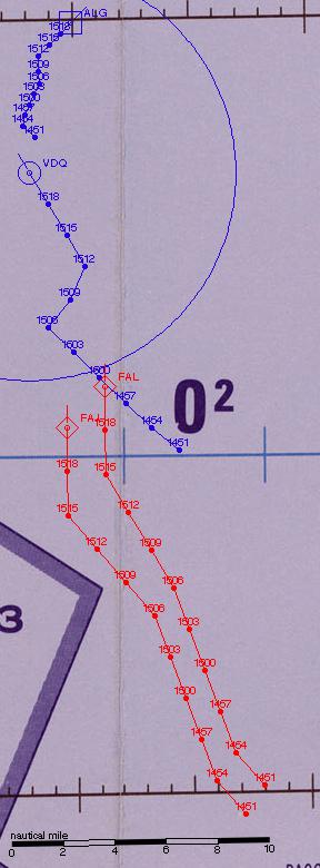
Ville de Québec returned fire with a spread of four Harpoons. They
locked on, two going after each PTG.
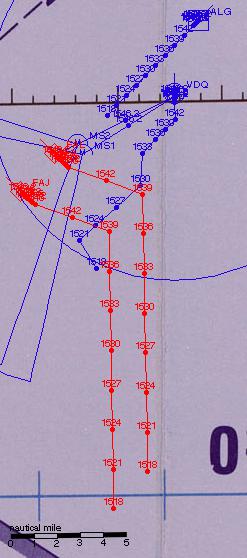
The PTGs' guns weren't up to the challenge of sea-skimming missiles
with terminal manoeuvres; one missile was decoyed away, but the other
three hit, sinking both boats.
Over the course of the next several hours, against the odds, the crew
of Algowest proved unable to bring the slow but steady flooding under
control, with the tanker eventually foundering at 0230 the next
morning.
A tactical victory to the Iranians, then (missile boats are cheaper
than tankers). Thanks to John (Red) and Tomasz (Blue) for being my
guinea pigs. Things I've learned from running this game:
-
Plotting the maps takes a while (30 seconds or so) since it has to
manipulate huge bitmaps, so I don't want to do it casually. (It's
far slower than working out new positions based on courses and
speeds, which takes a fraction of a second.) A range table in plain
text form lets me make decisions quickly (e.g. a player has said
"move unit A so as to keep ranges roughly equal between units X and
Y", and I want to know whether I've guessed at the right course), so
I've written a stripped-down version of the plotter which just
generates that.
-
It would be nice to have a syntax for conditions. For example, "let
me know when the range between unit X and unit Y is less than ten
miles" or "when the bearing from X to Y crosses Z". Then the system
could just roll time forward until such a condition was reached. In
practice, I did this manually.
-
Full NTDS symbology (with course, speed and possibly altitude), as
plotted in the examples I posted last time, makes the map too
cluttered when there's a history plot and units get close together.
Just a unit ID is enough; the history plot gives a visual impression
of recent courses and speeds. (Enemy courses and speeds should
probably be in the range table that's supplied to the players at
each decision point along with the map. Altitudes, too. Once I work
out a decent presentation format.)
-
On the other hand that history plot doesn't need to include the
whole game. Looking just back half an hour is a workable default
when we're in three-minute tactical turns. So that's what we've got
here.
-
It would be nice to be able to zoom in a bit, especially during
engagement turns. The TPCs are bitmapped, but I could scale up a
section for a larger plot and it probably wouldn't look too horrid.
This will take a while to sort out, though.
-
Conversely it would be nice to have an intermediate level between
the tactical picture as I've included it here and the full
60-megapixel chart, so that one can readily see the context of one's
units without having to find them on the full map. Perhaps expanding
the cropping margins on the tactical chart would help?
-
Aircraft fuel consumption is way more complex than it needs to be.
Next time I do this I'll start with a table for each aircraft of kg
of fuel used per tactical turn by throttle setting and altitude.
-
Once the missiles are flying, it all gets a bit sudden, and there's
not really scope for much player interaction.
-
Yes, all right, Tomasz, you were right and I'll use the
Smarter Radars
rules next time. But I need suitably revised range figures for the
Radar 998.
-
I'd be happier if I were using a "real" time system (e.g. POSIX
time) rather than just hours and minutes, just as I'm happier with
"real" latitude and longitude than with x/y plots on a table. As
things stand, if a scenario spans local midnight, everything will
get horribly confused; and the official system for representing
15-second time granularities, of HHMM.2, HHMM.5 and HHMM.7, simply
offends me. So I'll probably do that, and convert to a displayed
time as needed. (As a bonus, this will give me the possibility of
accurate sunrise/sunset calculations.) And if necessary, I can even
put each side's units in a different time zone (as happened in 1982
in the Falklands, where the British operated on GMT while the
Argentinians were running on their local time).
-
I want to do it again.
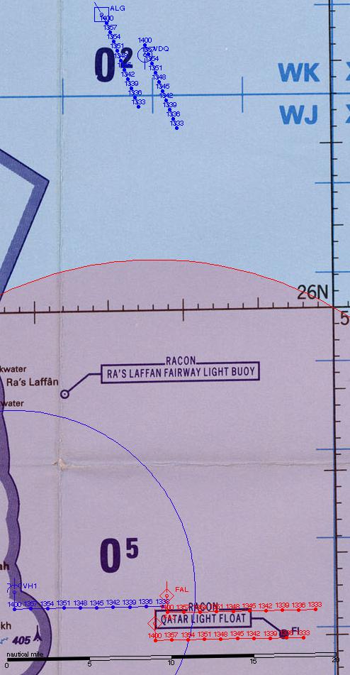
If you would like to see the full versions of the maps as seen by the
players, note that
they are now available here.
Comments on this post are now closed. If you have particular grounds for adding a late comment, comment on a more recent post quoting the URL of this one.