I've been playing with software-defined radio and broadcast aviation
data.
A couple of years ago I got hold of a cheap "DVB-T + DAB + FM"
USB stick, which is based on the RealTek RTL2832 chipset. (You can
tell it's a classy manufacturer - the USB-registered serial number is
"1".) This is meant to be a digital TV/radio tuner for Windows, but I
don't care about that: much more interestingly, it's a radio that can
be tuned and controlled by software.
The easiest way to capture data off it is not to mess about with the
full gnuradio toolchain but rather to use the RTL-SDR suite from
Osmocom (in Debian), which
comes with a number of pre-set utilities for common applications. Once
I'd verified it worked for plain old FM radio (very disconcerting to
hear The Archers after years of avoiding it), I chose to work with
ADSB, an aircraft traffic information system whereby aircraft
broadcast their position and other data. Sure enough, even with a
basic stubby antenna borrowed from an airband receiver (the ideal
simple antenna would be a 137.5mm dipole), up it came:
*8d400d8f3a5155e8d9d0fcc5f692;
*8d4ca6e390ab022dc1c3c7643ef8;
*90801530c0782030aa032010d79e;
*a0000a15d02a3f23a2c41ddee6f6;
*a0000a15a9080030680000d0ca48;
*a0001530b0e9e12ae01402828003;
*8545ac5099147c2060f882920d29;
Well, all right, that's recognisable but not entirely helpful.
Fortunately there are various decoders about, so I didn't have to
write my own; I chose dump1090
on the basis that it was open-source and not thoroughly tied to other
systems.
That can give you a live view overlaid on Google Maps, but more
interestingly to me it produces reasonably readable data in the
informally-defined SBS-1 format:
MSG,1,,,484B02,,,,,,KLM1069 ,,,,,,,,0,0,0,0
MSG,3,,,4CA9D2,,,,,,,13200,,,51.37125,-0.95039,,,0,0,0,0
MSG,6,,,4CA9D2,,,,,,,,,,,,,4465,0,0,0,0
MSG,3,,,4CA9D2,,,,,,,13125,,,51.36648,-0.94620,,,0,0,0,0
which I was able to capture, mangle a bit, and feed into a map
plotter. (Weirdly, none of this timestamps the captured data, so I did
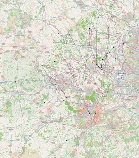
that myself.) Here's what I picked up for the hour between 20:05 and
21:05 last night:

Blobs represent the later ends of the tracks. You can see plenty of
aircraft coming westbound out of Heathrow, then turning north and
north-east on their standard routes. (Wind was out of the south and
west, and I didn't pick up any obvious landing aircraft.) Other
aircraft are in transit at higher altitude.
Reception would probably be improved if I didn't have the bulk of the
house between the antenna and points north. Even so: nifty.
Comments on this post are now closed. If you have particular grounds for adding a late comment, comment on a more recent post quoting the URL of this one.