I've been playing with Flightgear again, now with a decent joystick
and rudder pedals.
(I got my hardware purchase in just before all joysticks and
pedals vanished from Amazon because of the new MS Flight Simulator
release, which is nice.)
Given that I'm running Linux, MS Flight Simulator isn't an option (and
given how much of the new version has to be rendered by remote
machines it's effectively spyware too, if only in terms of the general
area you're flying in, though I suppose most gamers are used to much
worse). X-Plane is still going and available for Linux, and I think I
technically still own a copy, but it's still commercial, and many of
the interesting aircraft are payware too. Flightgear is entirely free
and open source, and so are all its add-ons.
Flightgear aims for realism in its flight models first, prettiness
later, which suits me very well.
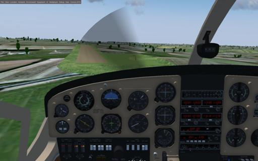
Here's an approach to Rayne Hall Farm airfield, near Braintree.

Not pretty. Nor is the modelling desperately precise; the airfield
isn't really on a little lump of ground like that, but the modeller
assumes that all airfields are flat.
Here is
what it actually looks like (looking from the other end, and with
snow).
On the other hand, the aircraft cockpit is an accurate 3d model of the
Cessna 337 I'm sim-flying, almost all of the switches work as they
should, the flight dynamics are pretty faithful, and – OK, note where
the plane is facing compared with the runway. That's not because I'm
incompetent. Down near the base of the propeller disc, directly above
the altimeter, you can see the windsock near this end of the runway.
At this point my aircraft is actually moving directly towards the
runway; the skewed angle is because I'm compensating for the
crosswind, and I'm going to touch the runway at that same angle and
have to put on a hard left rudder as the wheel contact changes my
direction. That's the sort of thing I care about more than how
accurate the airfield looks.
And that's the actual weather (not exact modelling but with the right
wind, cloud cover, etc.) that was happening there on the morning when
I was simming the flight.
FlightGear is also remarkably open and easy to interface with. I've
been writing code to read the scenery files for airports, navigational
aids, etc., and make them into overlays in the Viking GIS software, as
well as to talk directly to the simulator and track my progress. So
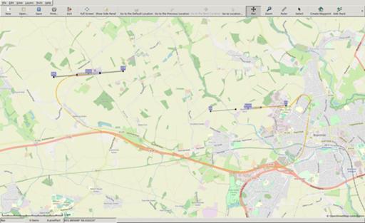
here's the track from that flight, overlaid with basic runway
information (details taken from the simulator's database rather than
OpenStreetMap that I'm using for orientation, so they don't quite
match):

I was able to pick up the A120 on my way out of Andrewsfield, the
previous airfield, then follow it by eye to the major road junction in
Braintree, turn north, and look around for the Rayne Farm strip.
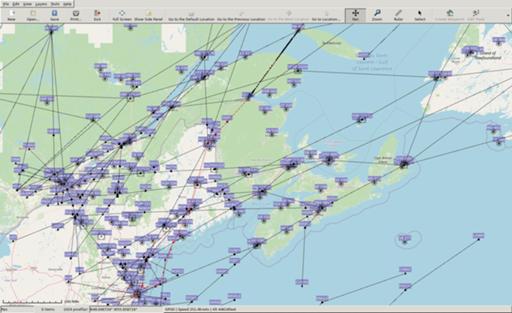
For something a bit more complex, here I'm about to start my descent
across New Brunswick in a Cessna Citation X (I prefer the light
business jets to the big airliners, because they can go to more
interesting airfields) on my way into Boston. Black lines are high
altitude airway routes, the labels are intersections and navigational
transmitters, and the red line is my planned route. The code which
generates my flightplan can dump it in Flightgear's native format for
use by its routeing engine as well as in something that Viking can
read.

This is a simulator, not a game – by which I don't mean to deprecate
either, but simply to say that any challenges are ones you set
yourself. There's no standard ladder of things to try; there's just
you, the aircraft, and the world. (Yes, all right, multi-player
flights are possible, but not on the big networks like VATSIM –
essentially because Flightgear is open and everything else that talks
to the VATSIM communications system is closed, so anything that would
work with both Flightgear and VATSIM would allow bad actors to inject
spurious data into VATSIM by means of a "fake" Flightgear.)
So my personal rules for keeping things interesting are:
- that I start at the nearest airport to where I live (which used to
be London City, but is now Wycombe Air Park) and expand my range
from there. I don't fly out of an airport until I've flown into it,
though not necessarily in the same aircraft or always starting from
the last place I landed.
- that I use current real time (though I'll allow myself some time
acceleration on long flights while I'm basically just waiting for
the autopilot to take me from waypoint to waypoint), and real
weather unless I'm deliberately making it worse.
- that as far as I can find out about them I obey real-world airspace
restrictions and procedures.
Comments on this post are now closed. If you have particular grounds for adding a late comment, comment on a more recent post quoting the URL of this one.