There's a new offline mapping program for smartphones, so I thought
I'd see how it stacks up against the one I'm already using.
For clarity: I'm using the F-Droid releases of both
OsmAnd and Organic
Maps. I believe
that OsmAnd charges for map downloads if you get it from other places.
Both programs work most readily with maps loaded onto the device in
advance (which is why I feel I should choose—I don't want to have maps
for both taking up space). Both of them run off OpenStreetMap data,
adapted into a custom format and published as roughly monthly updates
on their own servers. Both have a tendency to let you accidentally
rotate the map rather than locking north at the top forever. Both have
vaguely shadowy and possibly exploitative governance. How do they
differ?
Organic Maps is much newer and generally less featureful than OsmAnd;
conversely OsmAnd can feel bloated and over-complex.
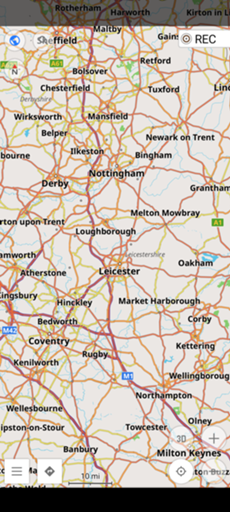
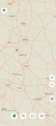
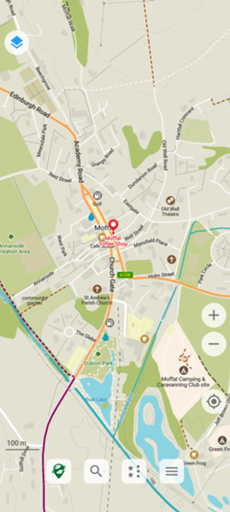
OsmAnd shows more information by default; Organic Maps is cleaner.
(OsmAnd is ferociously configurable, though.)
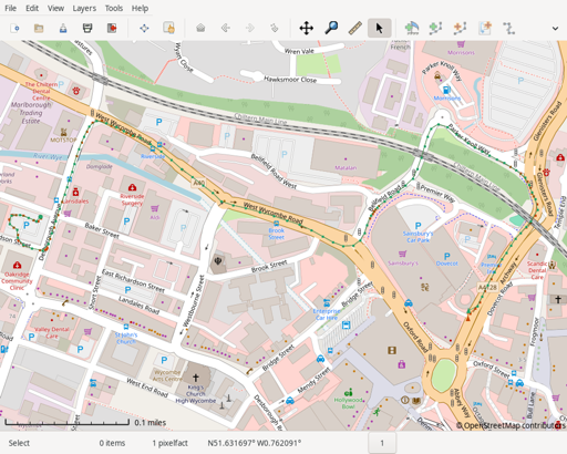
(All screenshots are taken on a Pixel 8 Pro; I've tried to line things
up to make views as similar as possible, but any error is mine.)
OsmAnd has standard map profiles; Organic Maps lets you bring in
specific layers for "Outdoor", "Hiking" etc.
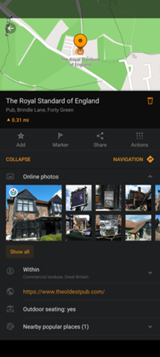
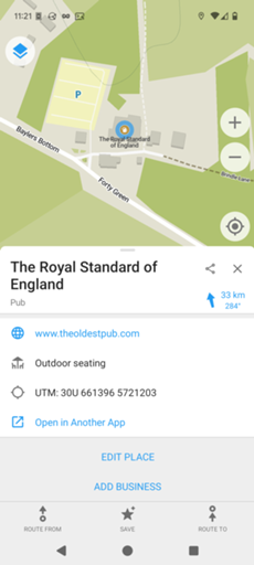
OsmAnd has the full OpenStreetMap data for objects; Organic Maps only
shows the object type. (The full data can include opening hours, not
always reliable but useful to have.) Correction: Ilmari kindly
pointed out that if you drag a thing which to me does not look
obviously draggable you get the full data. His screenshot below on the
right.
OsmAnd has a water navigation mode; Organic Maps doesn't. (I don't
often use this, but when I'm on a ferry I like to be able to see
what's nearby in terms of buoys and other navigation aids.)
Both programs allow one to add local place markers, and load them from
a GPX file. OSMAnd allows markers to be different colours and shapes,
and have different symbols in them; Organic Maps allows for a text
label, which I suspect wouldn't work well on OSM's busier default map.
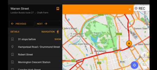
OsmAnd's public transport route finder uses bus data. Organic Maps'
doesn't. (The timings are anyone's guess.)
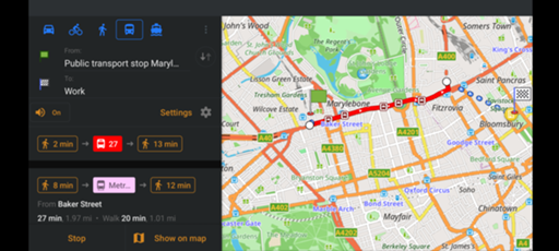
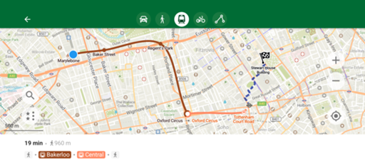
OsmAnd can even display a bus route and step through it stop by stop.
OsmAnd can be set to record tracks at configurable time intervals (I
use one second, which I know uses power but gives me the information I
want), and periodically (in my case every 60 seconds) upload position
information to a selected server; I wrote my own. Organic Maps can in
theory record tracks but only at its standard resolution (which
seems, to be every 16 metres or so), and can't call out to an
external site.
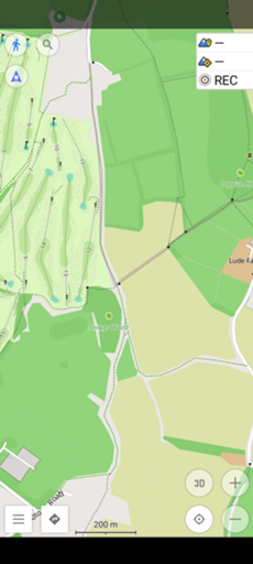
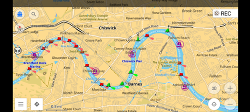
These are the tracks from a short drive in High Wycombe. OsmAnd's is
in red, Organic Maps' in green. (Both were exported as GPX and
rendered on the desktop in Viking.) Clearly
they're very similar; most of the time the green covers the red. But
observe, on the right, the cluster of red on Bellfield Road; and, on
the left, the cluster while turning off Desborough Avenue. Both of
these involved driving slowly, and the one per second recording of
OsmAnd captures this detail while the Organic Maps track loses it.
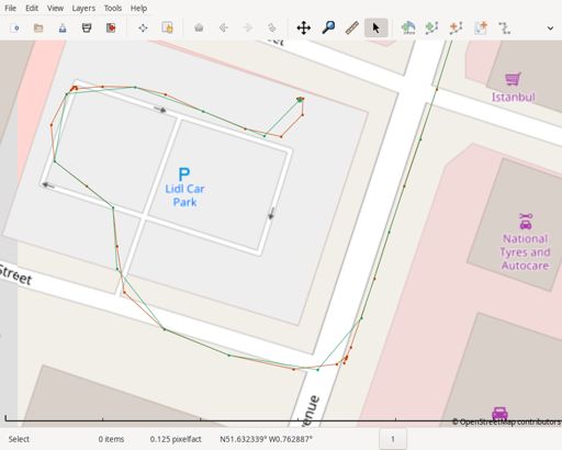
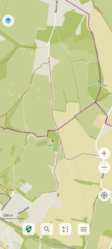
At the end of the trip, the intervals become even more obvious; at the
NW corner of the car park, I drove slowly while waiting for a clear
road, and Organic Maps loses that detail.
For my purposes I'll stick with OsmAnd for now, but I'm definitely
interested to see how Organic Maps develops.
- Posted by Leo at
09:15pm on
03 September 2025
Great writeup.
If you're looking to keep up with Organic Maps development going forward, I'd suggest following the recent fork CoMaps instead.
https://openletter.earth/open-letter-to-organic-maps-shareholders-a0bf770c
https://www.comaps.app/news/2025-05-12/3/
https://comaps.app/
https://news.ycombinator.com/item?id=44453888
- Posted by John Wilson at
10:12pm on
03 September 2025
I really appreciate this breakdown. I've heard people talk about Organic Maps recently, but haven't looked at the details and this is convincing me to at least give it a try.
OsmAnd is far too complex for its own good and I've accidentally put it into states that I can't get it back out again, or found some really useful feature that just as quickly disappears as far as I can tell.
- Posted by Mark Kéy-Balchin at
10:19pm on
03 September 2025
Just to note that Organic Maps also allows for colour selection, but you must tap the marker and press "Edit Bookmark". The bookmark also automatically takes on the icon of the object, but you can't change it manually.
I do find Organic's simplicity frustrating sometimes. I'd at least like to route a bus route, even if it doesn't do the schedule, and it seems to treat "stops" more like waypoints as it doesn't announce when you reach one - to be clear, I'd like a distinction between the two, because I use "stops" for both. But on the other hand, I do appreciate how uncluttered it is, and I really like being able to search for locations without Internet access.
- Posted by Bob Leponge at
10:20pm on
03 September 2025
Notice that OsmAnd allow to set up a profile for your vehicule (like a 8 meter RV, a Bus, a Bike, a 6 tons or 19 tons Truck), while Organic Map doesn't.
Also, Organic Maps has trouble mapping addresses to coordinates (it looks like their reverse street name doesn't work well) unlike OsmAnd.
Finally, it also disturb the phone lock screen (thus if you use your fingerprint to unlock the phone, the application is minimized instead of staying full screen), which is painful.
- Posted by stephan at
06:05am on
04 September 2025
note that Organic Maps has been forked, and the 2 are starting to diverge in term of features.
https://www.comaps.app/news/2025-05-12/3/
- Posted by pastk at
05:54pm on
04 September 2025
There is also CoMaps nowadays!
(forked from Organic Maps; if you're wondering - why a fork? - please check https://openletter.earth/open-letter-to-organic-maps-shareholders-a0bf770c)
- Posted by RogerBW at
07:16pm on
08 September 2025
Apologies for the slow appearance of comments — I've been away for a few days and new commenters need to be cleared by me.
I suspect what I really want is the feature list of OsmAnd and the clean display of Organic. Which I could probably get by poking at the OsnAnd profiles. I have just set up their third-party "hiking" profile which looks very promising so far…
- Posted by Stephan at
07:55am on
10 September 2025
For Osmand you may like this project providing alternative profiles with some improvements in each area.
They can be used in parallel.
https://osmand-rendering.github.io/index_EN.html
Comments on this post are now closed. If you have particular grounds for adding a late comment, comment on a more recent post quoting the URL of this one.